The Role of AIS Tracking Systems in Enhancing Maritime Operations
Tag: AIS
AIS Marine Traffic – AIS Tracking Systems Explained
How AIS Technology Transforms Maritime Safety and Efficiency
AIS for Avoiding Collisions
The introduction of GPS for civilian purposes led to the first AIS vessel tracking and identification system. AIS was developed by integrating GPS time and position data with long-standing VHF radio technology. Initially developed under the International Maritime Organization (IMO) in the 1990s, AIS was as a ship-to-ship anti-collision system for use in poor visibility and at night, in support of radar and conventional watch keeping. Over time, the amount of information that could be transmitted in the VHF signal grew and its usefulness increased.
In its early years, AIS was useful for (1) avoiding collisions, (2) acting as a traffic service and (3) providing coastal surveillance. Of these, the main purpose was to prevent collisions by allowing vessels to see who else is operating in their immediate vicinity, which primarily concerned large vessels at sea outside the range of shore-based systems. The technology identifies every vessel individually, along with its specific position and movements, enabling a virtual picture to be created in real time. This was achieved by providing information on the ship’s identity, type, position, course, speed, navigational status and other safety-related information. The AIS standards have further improved to include a variety of automatic calculations based on these position reports, such as Closest Point of Approach (CPA) and collision alarms.
Since not all ships have the system, AIS is usually used in conjunction with radar. However, the use of AIS is increasing, as international maritime law requires AIS transponders to be fitted aboard international voyaging ships with a gross tonnage of 300 tonnes or more, and on all passenger ships regardless of their size. Further, given its visibility and safety advantages, many smaller vessels also voluntarily install AIS units. The result is that AIS is used almost universally in the worldwide commercial maritime industry, and increasingly so in the leisure marine sector.
AIS Transceivers: Class A and Class B
Today, the AIS system consists of a VHF transmitter, two VHF TDMA receivers, a VHF DSC receiver, and a communications link to shipboard displays and sensors. It uses GPS for position and timing information, with data being broadcast automatically to ensure seamless ship-to-ship and ship-to-shore communication.
AIS transceivers are divided into two categories: Class A and Class B, each differing in the volume of data reported and the frequency of reporting. Class A transceivers, mandatory for all international voyage ships above 300 gross tonnage and all passenger ships, broadcast various information, categorized into static, dynamic, and voyage-related data fields. Dynamic information, such as the ship’s speed and location, is transmitted every 2–10 seconds while underway and every 3 minutes while at anchor. Static and voyage-related details are shared every 6 minutes. In contrast, Class B transceivers, often used by smaller, primarily pleasure, vessels, transmit a reduced set of data at less frequent intervals. This differentiation ensures that the vast network of maritime traffic can communicate effectively, tailoring data sharing to the operational needs and capacities of different vessel types.
You can schedule a meeting with our representatives and get a consultation on how you can achieve a better operational efficiency: Schedule a Call now.
Evolution of AIS Data Collection
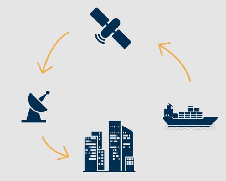
To improve the management of AIS marine traffic, the original AIS system relied heavily on direct ship-to-ship, ship-to-coast, and coast-to-ship communication within the very-high-frequency (VHF) radio wave range. This method, however, only covered 10–20 nautical miles, making AIS data difficult to collect and highly regionalized. Despite the limited horizontal range, AIS tracking systems have a much longer vertical transmission range, reaching up to 400 km. This enabled the significant leap forward in 2008 when AIS receivers were deployed on satellites. This development vastly increased the range, as satellites equipped with AIS receivers began to capture data transmitted by onboard AIS transceivers globally, enhancing the effectiveness of AIS tracking systems.
These satellites have dual roles. In busy port areas, they supplement terrestrial AIS receivers, enhancing AIS marine traffic management by providing comprehensive global coverage. Otherwise, ports risk becoming overwhelmed by the sheer volume of data from numerous vessels. Globally, they facilitate the collection of AIS data in almost real time, bridging the gap left by the limited range of terrestrial systems. Today, a number of online suppliers, leveraging the ship locator AIS feature, allow users to enter the names of vessels and find their locations on maps together with varying amounts of vessel and environmental information. Offshore positions collected via satellites are inherently more expensive, and typically available on commercial websites. This reflects the constantly improving quality and completeness of AIS data, showing how AIS has gone from direct ship-to-ship communication, evolving into offering a global perspective on maritime traffic.
The Diverse Applications of AIS Data
Although the initial purpose of AIS was solely collision avoidance, improvements in the range and the accuracy of data, have extended its purpose beyond navigation safety. Today, AIS data serves as a crucial element in the digitization of shipping, providing high frequency, real-time positioning, and sailing patterns for almost the entire world’s commercial fleet. This data on AIS Marine traffic has initiated various research and operational improvements, useful to all areas of the industry.
The Value of AIS Data in Tugboat Fleet Management
One of the areas where AIS data has proven to be valuable is in tugboat fleet management. The efficiency and operational optimization of tugboats hinge on a deep understanding of maneuver services’ characteristics. Through ship locator AIS data, maritime operators can acquire real insights into service times, enabling the optimization of schedules based on real data points. This optimization not only enhances the efficiency of tugboat operations but also ensures that the number of tugboats assigned to a maneuver is precisely calculated, fostering cooperation and reducing idle time. For a detailed exploration of how AIS data can revolutionize tugboat fleet management, enhancing operational efficiency and strategic scheduling, delve into our article dedicated to this topic.
Read more about Tugboat Fleet optimization here:
Efficient Tugboat Fleet Management Analytics: Implementing a Tugboat Tracker System Photo by Elijah Mears on Unsplash Optimizing Tugboat Operations: The Power of …
AIS Data for Reducing Tugboat Fuel Consumption
Another way in which AIS data can play a critical role, is in reducing tugboat fuel consumption, a concern resonating with the industry’s growing focus on sustainability and cost-efficiency. The accurate and real-time data provided by AIS allows for analysis of tugboat operations, identifying areas where fuel consumption can be minimized without compromising on service quality. By understanding the movement patterns and operational characteristics of tugboats, operators can implement strategies that lead to significant fuel savings, contributing to sustainability and operational cost reductions.
To discover more about the impact of AIS data on optimizing fuel consumption in tugboat operations, click the link below:
Waste Free Shipping Content How do We help You Reduce Fuel Consumption And Decarbonize?Effective software that helps you reduce fuel consumptionThe Value You GetWhy our product is effective – The …
These expansions in the application of AIS data underscore its potential not only as a tool for navigation safety but as a cornerstone for the digital transformation of maritime operations. The continuous improvements in the quality and accessibility of AIS data promise to unlock further innovations in the industry, paving the way for more efficient, sustainable, and cost-effective maritime operations.
Getting Started: Access to Quality AIS Data
The introduction of terrestrial and satellite data has been instrumental for improving the coverage of AIS tracking system. It has enabled AIS data on maritime traffic. The developments in the accuracy and range of AIS data has without a doubt made it one of the most valuable information sources available for anyone involved in the maritime sector.
While satellite AIS data ensures global coverage, the data itself is not of sufficient granularity to enable the previously described analyses on its own. In cases where current terrestrial coverage is not sufficient to conduct the above-described analyses, one can choose to set up a proprietary collection system. LionRock Maritime can facilitate this. You will get your own receivers that are not linked to any commercial data source, so your data is kept confidential.
This AIS tracking system is a cost-effective solution, and can be used by tugboat, workboat and port operators looking to enhance their operational efficiency through better data access. The tool stands out by offering lower data costs, eliminating the high subscription fees often associated with third-party data services. By owning the hardware, operators gain direct control over data collection, ensuring improved data quality and accuracy, through higher frequency. Installation is straightforward. Like every AIS system, the receiver requires a stable internet connection via LAN cable is required and a connection to the vessel’s VHF antenna via a COAX cable. A picture of LionRock Maritime’s AIS receiver can be found below.

Conclusion
AIS has grown from its origins as an anti-collision system to become a fundamental part of maritime navigation and safety. Its evolution, especially with the integration of satellite technology, has broadened its reach and utility, enabling ships to communicate and operate safely across the globe. As we move forward, AIS is set to continue playing a key role in enhancing maritime operations. Its journey from a basic navigational aid to a global tracking system reflects the maritime industry’s progress towards more digitalized and efficient practices. AIS is not just a technological advancement; it’s an essential tool that keeps the maritime world moving safely and efficiently.
Gather your own data and improve your operational performance with LionRock
Ready to enhance your maritime operations with AIS data from LionRock Maritime’s tracking system? Our receiver is easy to install and designed for tugboat operators seeking to improve operational efficiency through better data access. With our solution, you gain direct control over data collection, ensuring improved accuracy, increased privacy, and higher frequency data. Discover how LionRock Maritime’s AIS tracking system can transform your maritime operations today!
Frequently Asked Questions
What is an AIS tracking system?
How does the ship locator AIS work?
Why is the AIS tracking system important for maritime operations?
How has the use of ship locator AIS evolved?
Related Topics
Tugboat Industry Growth and Strategies: Navigating Emerging Markets with Data Insights Foto von Dwi Cahyo auf Unsplash Navigating the Tugboat…
References
- AIS shortcomings and the tracking alternatives
- AIS vs radar: Do you really need both?
- What is the Automatic Identification System (AIS)?
- Tugboat resting location optimization using AIS data analysis
- What is Automatic Identification System (AIS)- Types And Working (FAQs)
- AIS transponders (IMO)
- Analysis of Tugboat Activities using AIS Data for the Tianjin Port
- How big data enriches maritime research–a critical review of Automatic Identification System (AIS) data applications
Related Posts
How to Become a Tugboat Captain: A Comprehensive Guide | 2025
A Comprehensive Guide to a Rewarding Career in Maritime Operations How to become a Tugboat Captain Becoming a tugboat captain is more …
Shipping Alliances: Gemini Cooperation shifts tugboat demand in 2025
How Shipping Alliance Restructuring and Market Insights Shape Tugboat Demand and Fleet Optimization Introduction – Change Within Shipping Alliances and Its Impact …
The Business of Towing: Job Costing Insights
Cost to serve on tugboat jobs In the competitive world of maritime services, understanding the cost to serve is crucial for towage …
Diesel Tugboats and Advanced Biofuel: An In-Depth Look at the Integration of Biodiesel
Introduction – Biofuel to power diesel tugboats The maritime industry is undergoing a significant transformation as the European Green Deal and the …

